
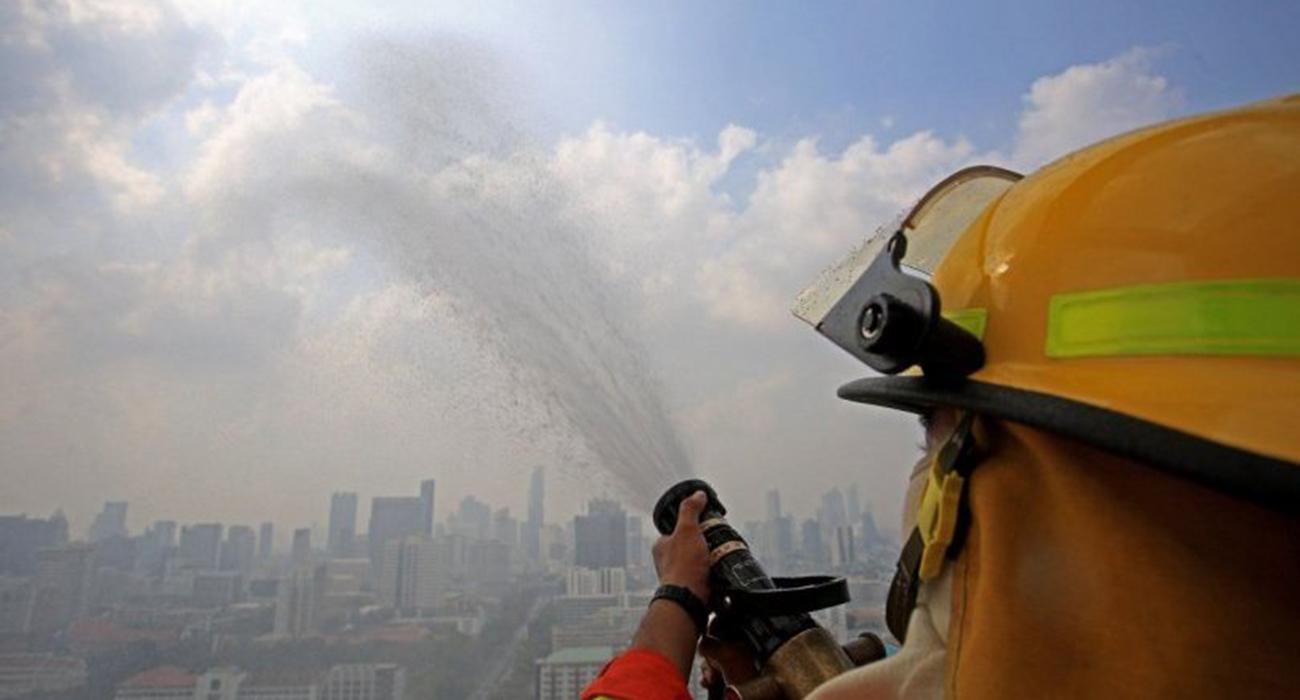
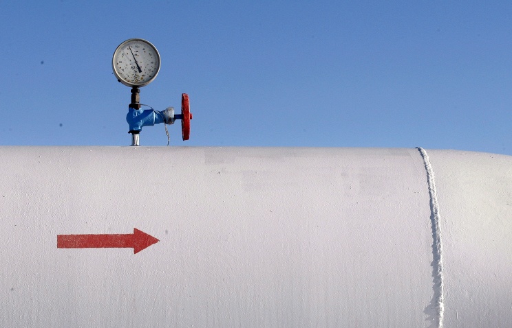
  BANGKOK, February 2 -- Thai government has apologised to Bangkok citizens about the air pollution that continues to disrupt their daily lives and is threatening their health.
The amount of harmful PM2.5 dust particles in the air has exceeded the safe limit in the capital and adjacent provinces almost daily since late December. The blue sky typical of this time of year is hidden beyond a grey-yellow haze that could have serious long-term effects on health, and emotions are starting to burn along with the waste and cropland fires that contribute much to the problem. Residents have been venting frustration on social media, complaining about difficulty in breathing and pressing hard for the government to do more to solve the problem in a concrete manner. However, the Bangkok Metropolitan Administration (BMA) and relevant authorities have taken some action to ease the problem in areas under heavy smog. For instance, they have been trying to crack down on vehicles emitting black fumes and are becoming strict with people burning fires outdoors. Officials have also started keeping a close watch on industrial plants, ensuring there are no toxic fumes coming out of their chimneys. Roads are being regularly hosed down and water is being sprayed in the air in the unsubstantiated hope of bringing down the dust particles. “The government apologises for the inconvenience caused and would like to thank everybody for support and cooperation,” Prime Minister General Prayut Chan-o-cha said in a statement on Friday. He also called on owners of diesel-run vehicles to only use their cars in Greater Bangkok when it is absolutely necessary. “If possible, avoid using them until the smog eases,” he advised as he agreed that the main cause of the haze could be put down to incomplete engine combustion. “As a long-term solution, we will improve the integrated public-transportation system, fuel quality and exhaust fume standards. We will have more petrol stations offering environmentally-friendly choices and start promoting hybrid or electric vehicles,” the premier said.
0 Comments
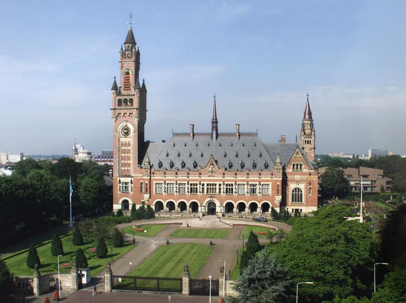
  KATHMANDU, January 25 -- The trans-Himalayan village of Halji is a small collection of about 80 closely packed mud-and-stone houses at the base of a moraine hill.
Steep cliffs rise on either side of the village that is flanked by a glacial stream on its left. By contemporary standards, Halji is extremely remote. It is snowed in and cut off for six months of the year during winter and does not have mobile network connectivity. The district headquarters, Simikot, is a five-day walk away. And getting to Kathmandu involves an expensive flight from Simikot. But for centuries before, the three villages of Limi Valley - Halji, Til and Jang - were the focus of a vibrant caravan trade with neighbouring Tibet and part of the larger sacred landscape surrounding the holy Mount Kailash and Lake Manasarovar. Located in far western Nepal on the border with China, Limi Valley is an isolated but historically significant region where ancient Tibetan Buddhist culture thrives due to its proximity to Tibet. At the centre of this rich heritage is the famous 1,000-year-old Rinchenling monastery. Both the valley's largest village, Halji, and Rinchenling monastery - the cultural and spiritual centre of Limi - are threatened by climate change today. "Rinchenling is the oldest and biggest monastery in west Nepal," says Tsewang Lama, an anthropologist and the only parliament member from this district in Nepal. "Out of 21 students sent by the king of Guge in west Tibet to translate the texts from India's Kashmir, during the second renaissance of Buddhism, only two returned - one of whom went on to become the famous translator Rinchen Zangpo (958 - 1055). He built 108 monasteries in his life, one of them is this." Rinchen Zangpo is widely accredited with the second renaissance of Buddhism in Tibet and Halji's Richenling is one of the last few surviving monasteries from that period. The rest were destroyed during the Cultural Revolution, which began in Tibet in 1959.   SHANGHAI, January 24 -- Workers conduct quality check on mulberry alcohol in Gaoqing County, east China's Shandong Province.
The cultivation of mulberry trees and silkworms is a long-standing agricultural practice in Gaoqing County. In addition to a market-oriented business strategy, the local authorities encourages innovation and research to develop a green and sustainable mulberry-related industry, which not only produces mulberry leaves, but also turns out silk fabrics, mulberry leaf tea, mulberry alcohol, dried mulberry fruits and other derivative products. China has pledged to coordinate its efforts of environmental protection and economic development in 2019, an important year for winning the tough battle against pollution. At the annual Central Economic Work Conference earlier this month, authorities called for building on this year's achievement in pollution control, making more efforts and input in 2019. Since the turn of this year, China has made solid efforts to combat pollution and seen constant improvement of the environment. The Central Economic Work Conference made it clear that local governments must avoid past simple and unscrupulous practices in dealing with environmental problems.   ROTTERDAM, January 24 -- A very large and deep trough dominates Mediterranean region, partly also central Europe, north Africa and the western Balkan peninsula.
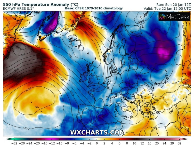
Very cold airmass maintains across the Alps and also spreads across the western Mediterranean and reaches north Africa (northeast Algeria and north Tunisia) as well. A very deep surface cyclone is located over the Tyrrhenian sea and results in strong southerly winds across south Italy and the Adriatic sea, bringing excessive rainfall/snowfall threat into the region. Warm weather across the southeast Europe continues. 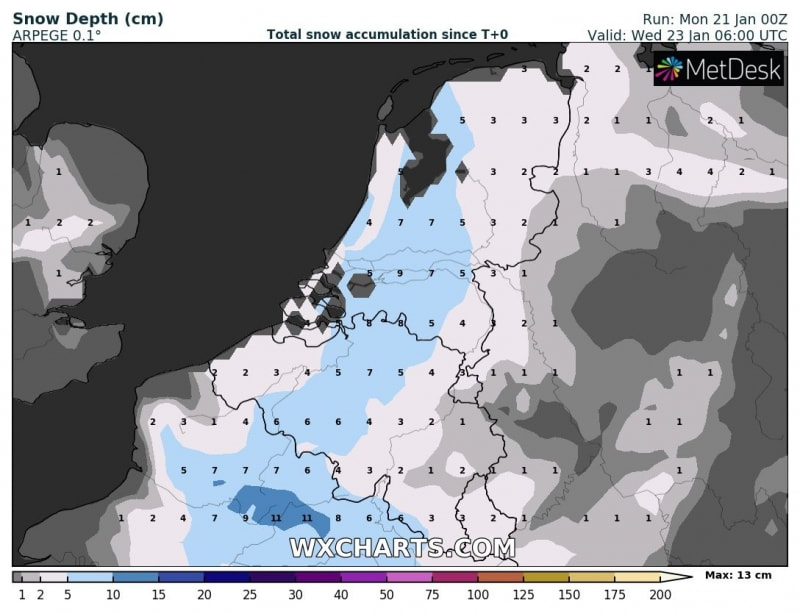 ROTTERDAM, January 22 -- A detailed look at snow depth across Benelux until Wednesday, Jan 23rd based on GFS,
CON-EU, ARPEGE and HIRLAM models – a widespread blanket of a few centimeters of snow is likely. The ARPEGE model is the most aggressive with up to 10 cm of snow in parts of the Netherlands.  DAVOS, January 22 -- This week the annual World Economic Forum (WEF) will bring business leaders from around the world to the Swiss town of Davos, and Air Charter Service predicts there will be close to 1,500 private jet flights over the week.
Andy Christie, Private Jets Director at ACS, said: “The global interest in the event led us to analyse the private jet activity over the past five years of WEF. Davos doesn’t have its own airfield and, whilst we have several clients who fly into the town by helicopter, the four main airfields that private jet users attending the forum use are Zürich, Dübendorf, St. Gallen-Altenrhein and St. Moritz. “Working with WingX, we looked at private jet activity at those airports over the six days of each WEF week since 2013 – from one day before the event to one day after. Last year was the busiest year for private jets so far, showing an 11% increase on 2017, with more than 1,300 aircraft movements. If we see a similar increase this year, we could be looking at almost 1,500 aircraft movements over the six days. “The week of the forum is unlike any other busy private jet event, such as the Super Bowl or Champions’ League final – it’s unique for the industry in that we receive bookings from a number of our offices around the world, rather than just the one or two offices in the region where the event is being held. We have had bookings from as far as our operations in Hong Kong, India and the US – no other event has the same global appeal. “Top countries involved in terms of arrivals in and departures out of the local airports over the past five years have typically been Germany, France, UK, USA, Russia and UAE, in that order. There appears to be a trend towards larger aircraft, with expensive heavy jets the aircraft of choice, with Gulfstream GVs and Global Expresses both being used more than 100 times each last year. This is at least in part due to some of the long distances travelled, but also possibly due to business rivals not wanting to be seen to be outdone by one another.” 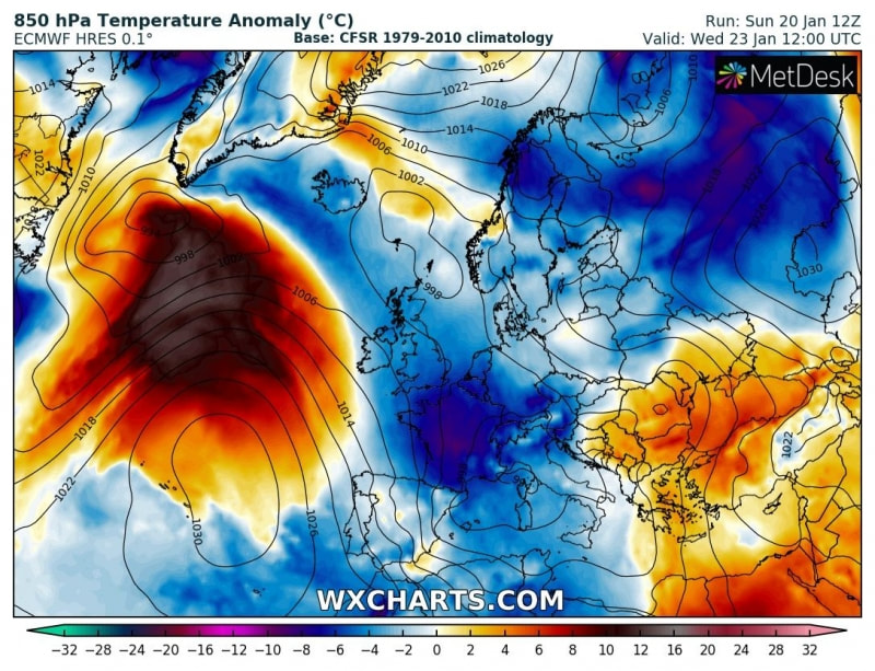  ROTTERDAM, January 22 --The trough over northwest Russia dissipates while the trough from the western Europe significantly strengthens while moving across France towards the Mediterranean. In response, a large deepening cyclone expands across the Mediterranean and central Europe. Much colder airmass advects behind the trough into France, the Alps and the northwest Mediterranean. The ex-Noreaster’ cyclone from the northeast United States pushes towards Greenland and brings significant warm advection across the northern Atlantic. Warm advection brings milder weather into the southern Balkan peninsula and the southeast Europe. 
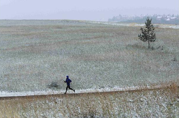
  ROTTERDAM, January 21 -- A deep trough from the north Atlantic pushes into the western Europe while the deep trough over northwest Russia pushes further east and an intense cold outbreak moves into western Russia. With the advection of much colder airmass into western Europe, the trough over the Mediterranean begins strengthening and cyclone deepens over the central Italy. Cold weather maintains across the west, southwest, central and southern Europe. Attached are some of the more interesting days regarding the possibility of falling snow across our continent:
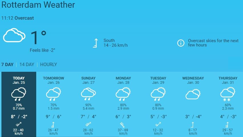
 Snow forecast for Tuesday, January 22 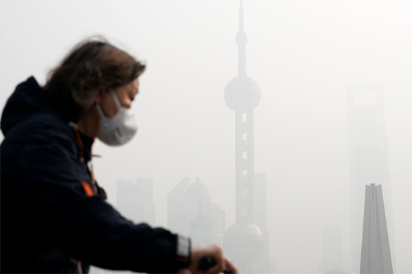  BEIJING, January 20 -- China has met its annual target for pollution control in 2018, with more blue skies, cleaner waters and greener mountains.
"We have successfully delivered all the obligatory targets set for 2018 and stayed in line with the timetable outlined by the 13th Five-Year Plan," Chinese Ecology and Environment Minister Li Ganjie said during a work meeting that concluded Saturday. Air quality has continued to improve with 338 major cities reporting good air quality on 79.3 percent of days, up 1.3 percentage points from the previous year, official data showed. The density of PM2.5, a key indicator of air pollution, dropped by over 10 percent in 2018 from the previous year in three heavily-polluted areas, including the Beijing-Tianjin-Hebei region. In terms of soil pollution control, Li said the country had reduced solid waste imports by 46.5 percent year on year, finished overhauls of all subpar garbage power plants and launch sweeping crackdown on the illegal transportation and dumping of hazardous waste in 2018. Thorough action has been taken to clean up 1,009 "black and malodorous" water bodies in 36 major cities and 1,586 water sources, Li said, adding that "defense of lucid waters" would be a primary task for 2019. China has pledged to coordinate its efforts on environmental protection and economic development in 2019. At the annual Central Economic Work Conference held in December, authorities called for building on the achievements of 2018, making more effort in 2019. One of the key challenges, analysts said, is finding ways to engage in pollution treatment without harming productivity. Zhang Liqun, a researcher with the Development Research Center of the State Council, said the conference offered targeted prescriptions. The conference made it clear that local governments must avoid the simple and unscrupulous practices of the past when dealing with environmental problems. "This will give better support to balancing environmental protection with economic development and realizing mutually-enhancing interaction," Zhang said. In 2019, China will put the Yangtze River restoration project in full swing, clean up more "black and malodorous" water bodies, achieve environment improvement in the Bohai Sea through comprehensive measures, and launch a water quality campaign in rural areas, Li said. The country will also further reduce imports of solid waste and push for better air quality with better regional coordination and heavy-polluter revamps, according to the minister. 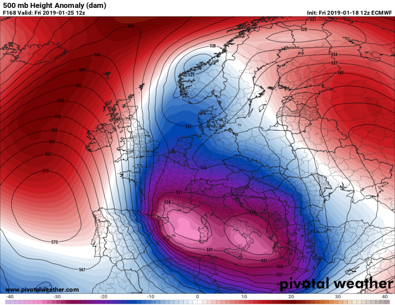 Temperature development to Friday. January 25  ROTTERDAM, January 19 -- As discussed in one of our previous outlooks, the significant results of a Sudden Stratospheric Warming and related Polar Vortex split earlier this month, are now coming into effect. Next week, a strong ridge / high pressure system strengthens over the Arctic region while a very dynamic pattern establishes across western, central and southern Europe. A channel / corridor from the northern Atlantic will develop a ‘train of deep troughs / systems’ moving across western Europe towards central Europe and the Mediterranean – this will significantly enhance winter weather with severe phenomena as well, including flooding, intense snowfall and blizzard conditions in some regions. The pattern evolving this weekend will gradually intensify next week. Ridging over the Arctic region will strengthen and allow systems to develop over the western Europe and intensify on their way towards the Mediterranean. A deep trough develops over the UK on Tuesday and rapidly deepens while moving across France on Wednesday, Jan 23rd. The trough becomes a really big and particularly extremely deep system when it enters the central Mediterranean on Thursday. A day after, it remains generally over the same region while gradually moving towards the Balkan peninsula. In response to the deep trough across central and southern Europe, much colder weather is expected for the western half of our continent. New, much colder airmass pushes across the western Europe on Tuesday. Cold air advection intensifies on Wednesday when the parent trough significantly deepens on its way towards the north Mediterranean. On Thursday, the trough develops a very deep cyclone across the central Mediterranean and an intense cold outbreak spreads across the region. The pattern then establishes a textbook corridor of a very strong meridional flow, delivering extremely cold maritime airmass directly from the Arctic region across west-central Europe towards the Mediterranean over the weekend days.  Air pressure development to Friday. January 25 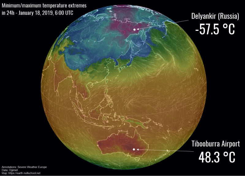  ROTTERDAM, January 19 -- Temperatures plunged down to -57.5 °C in Delyankir (Oykmyakonski District, Sakha Republic) in far eastern Russia last night.
This part of Russia is the one of the coldest places on Earth and the coldest inhabited area – the (fairly) nearby Oymyakon holds the official lowest recorded temperature in the northern hemisphere: -67.7 °C on February 6, 1933. Meanwhile parts of Australia have been undergoing a scorching heat wave. Yesterday temperatures peaked at a blistering 48.3 °C at Tibooburra Airport (NSW), while a number of stations recorded peak temperatures above 45 °C. The official highest temperature in Australia recorded so far was 50.7 °C in Oodnadatta on January 2, 1960. The record for the highest minimum (night) temperature was broken last night: Noona (NSW) recorded a minimum temperature of 35.9 °C, as reported by the Bureau of Meteorology, New South Wales.  LONDON, January 17 -- Millions of Britons are bracing for the coldest night of the year tonight as weather warnings are issued for snow and ice across large swathes of the country.
Temperatures could plummet as low as -11C in some areas of the Scottish Highlands on Thursday night, while even central London could see the mercury fall to -2C. The freezing night across most of the country will follow a day in which the Met Office has warned of severe winter weather for much of the UK. All areas apart from Cornwall and southeast England have been told ice could bring travel delays and risk of injury. Hills more than 200 metres above sea level in Scotland look set for significant snow. Parts of London and southern England also saw a small amount of snow fall early on Thursday morning. “It’s going to be a very cold day, most places will be a good 5C colder than they were yesterday,” Met Office forecaster Simon Partridge told said. “This afternoon, you are only looking at highs of around 3C in places like Cardiff and even in London it may only reach 5C. “Thursday is likely to be the coldest night of the week, most areas will be below freezing, central London will be down to –2C, in some spots of rural Scotland we may see -11C. “If that does happen it will be the coldest night of the year. The current record is -10.5C in Braemar in Aberdeenshire and if that is broken its likely to be by somewhere in that general area.” Although cold, most areas will stay dry on Thursday, but Friday will see a band of rain slowly moving in from the west, bringing showers to Northern Ireland, Wales and southwest England. Hill snow could fall in Northern Ireland and Wales, although this is not likely to be widespread enough to disrupt travel networks. Into the weekend, temperatures are set to stay below average for the time of year, with more rain and hill snow predicted in western areas but conditions will stay drier in the east.  ROTTERDAM, January 17 -- Global models are now in very good agreement about the cold weather through second half of January, the results of Polar Vortex split earlier this months are coming into effect for the lower troposphere. Cold winter weather should spread across the western half of Europe as a favorable pattern establishes after this weekend. Ridge over the northwest Atlantic with deep troughs across western towards southwestern Europe should bring both very cold and snowy weather locally. The first event will be a cyclone passage across the UK and Ireland this Friday, arriving just a day after the cold outbreak across the region. Despite the quite strong warm advection associated with the frontal system, the airmass should remain quite cold! 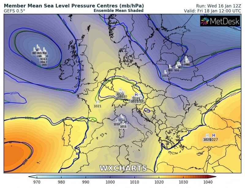 Models are therefore hinting at some snow through Thursday night over parts of Ireland while some additional chances for Scotland and England come on Friday afternoon during the front passage. 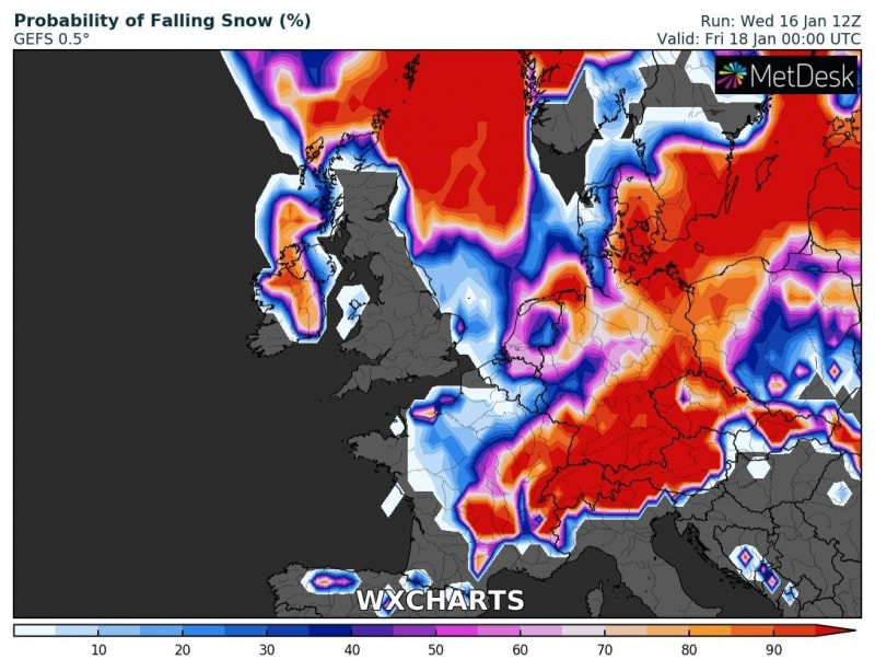 The pattern next week continues with very dynamic systems – on Sunday a trough develops over the western Europe and brings more cold weather across western, central and southwestern Europe. Towards the middle of the week, the upper ridge over the Atlantic strengthen,s but retreats towards the North American continent which will allow more strong cold advection into western Europe. As a result, a trough then strengthens / deepens and moves further into the southwest Europe 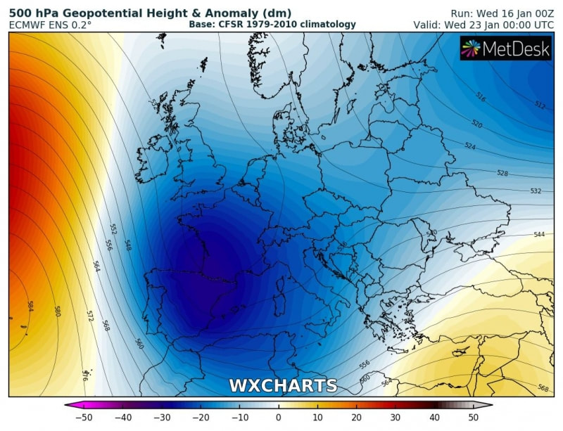 Very cold airmass should then maintain through most of the week while also reaching Iberian peninusula, western Mediterranean and even North Africa again 
WESTBROOK, January 16 -- A massive disc of ice has formed in the Presumpscot River in Westbrook, Maine, a suburb of Portland.
Tina Radel, Westbrook’s marketing and communications director, posted images of the Westbrook Ice Disc on social media, saying the ice is slowly rotating counter-clockwise and that birds have been using it as a resting area. “It looks like the moon has landed in Westbrook!” the city wrote on Facebook. No exact measurement of the Westbrook Ice Disc has been taken, but in video shot from a drone and shared by the city, it appears larger than two nearby downtown buildings. |
Thank you for choosing to make a difference through your donation. We appreciate your support.
Categories
All
Archives
April 2024


|

 RSS Feed
